-
Technology
-
Industry
-
Solutions
-
- ASSET MANAGEMENT
- CUSTOMER EXPERIENCE MANAGEMENT
- CYBER SECURITY
- DATA CENTER
- DOCUMENT MANAGEMENT
- ELECTRONIC DATA INTERCHANGE
- ENTERPRISE DATA MANAGEMENT
- ENTERPRISE RESOURCE PLANNING
- ENTERPRISE RISK MANAGEMENT
- ENTERPRISE-GRADE WEB DATA SOLUTIONS
- FACILITY MANAGEMENT
- FIELD SERVICE
- IDENTITY AND ACCESS MANAGEMENT
- INFRASTRUCTURE
- IT SERVICE MANAGEMENT
- MANAGED IT SERVICES
- PAYMENT AND CARD
- PROJECT MANAGEMENT
- SOFTWARE TESTING
- STORAGE
- VIDEO SOLUTIONS
- WORKFLOW
-
-
Platforms
-
Functions
- Leadership Perspectives
- Innovation Insights
- Research
- Magazines
- News
- CXO Awards


Cautro Conceptos®- Technology Development Center
Turning Geospatial Intelligence into Territorial Decisions

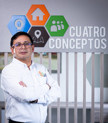 Hector Mauricio Ramirez Daza, Research, Development and Innovation Manager
“We want to understand what is happening in the territory and transform that information into decisions for the future,” says Hector Mauricio Ramirez Daza, Research, Development and Innovation Manager.
Cuatro Conceptos® - technology development center combines technological development and research with a client-first process, starting with what a client needs to understand before determining how information should be captured. Terrain, scale, accessibility and project objectives guide the choice of technology, from topographic surveys and satellite imagery to drones and aircraft. Datasets can include terrain and surface models, orthophotography, LiDAR, point clouds and mapping. Processing and validation bring those sources together into a complete geographic picture that often supports applications beyond a single project.
The company works with small municipalities as well as territories covering millions of hectares across Colombia and Latin America. A smaller municipality may demand resolution and precision, while a larger territory may require technologies capable of covering larger areas. Allied companies add specialized capabilities when needed.
Access can be as important as technology. In remote areas that require long journeys and may be of difficult access even for state institutions, the team may examine sources, including radar, before coordinating with mayors, community action boards, churches and local representatives.
Bringing together these technical and field-based requirements calls for experience in geographic information and planning. Hector Mauricio Ramirez Daza, who leads research, development and innovation at Cuatro Conceptos® - technology development center, brings more than 22 years of experience in the field. A forest engineer with a master’s degree in geography, he has also worked at Colombia’s Agustín Codazzi Geographic Institute.
When Geographic Data Meets Local Knowledge
La Mojana ecoregion offers an example of geospatial work connected to the realities of a place. In this area, three rivers (Cauca, Magdalena and San Jorge) converge and create a unique ecosystem where communities live in constant interaction with the flows of the water. There has been increasing stress due to changing water patterns, environmental disasters and socio-environmental pressures, which have affected local livelihoods.

We want to understand what is happening in the territory and transform that information into decisions for the future.

Cuatro Conceptos® - technology development center was brought in to help Fondo Adaptación "a state institution working on risk reduction" understand those conditions. Its work combined hydrological, hydraulic and hydrodynamic models with hydro-sedimentological simulations. Additionally, high-resolution imagery and field data supported topographical models that brought together terrestrial elevation and the makeup of the underwater riverbed.
The resulting information gave Fondo Adaptación a detailed understanding of the territory and a basis for mitigation strategies. Cuatro Conceptos® - technology development center trains people to understand the datasets they receive and work with them independently, while institutional collaborations can include methodologies, publications and research papers that support further research and informed decision-making.
Making Geospatial Expertise More Accessible
Cuatro Conceptos® - technology development center has also developed XphereLab, an AI-based a cloud-based GIS platform that brings geographic data and visualization into one space. The platform helps users from the wider public understand their territory and apply the data.
XphereLab is part of a broader body of work that Cuatro Conceptos® - technology development center has developed over 12 years, working across the Dominican Republic, Panama, Canada and Peru. The company has worked with the United Nations Development Programme, the World Bank and Colombia’s Geographic Institute, alongside companies and universities.
Cuatro Conceptos® - technology development center has built its work around a simple premise: geographic information matters most when people can understand it and use it. Maps, models and datasets provide the foundation to understand a territory, but their value grows when institutions and communities can turn information into informed decisions. Connecting government, communities, geographic information and academic knowledge gives that information a life beyond the original project, helping it contribute to decisions, research and future understanding of the territory. It is an approach that has earned the company recognition as the Top Geospatial Technology Firm in Latin America in 2026.
When Geospatial Data Must Support the Next Decision
A geospatial survey can cover thousands of hectares and still leave a client with questions about the terrain. Much depends on how the information is collected, processed and presented. In some projects, the main concern is reaching an area that is difficult to access. In others, it is combining different datasets or making sure the results remain useful after the survey is complete. These practical differences are worth considering when selecting a provider.
The area being surveyed often determines how the work unfolds. Mapping a municipality, for example, presents different problems from surveying a remote rural region. Buildings, vegetation, ground conditions and access all influence the choice of equipment and methods. Satellite imagery may be enough for one assignment, while another requires drones, crewed aircraft or measurements taken on the ground. Buyers should ask how a provider makes these choices and whether it can maintain consistent accuracy when a project expands. A larger survey should not automatically mean longer delays or less reliable results.
The work does not end when the measurements have been collected. Elevation models, orthophotography, LiDAR and point clouds each provide different information, and combining them takes careful processing. Errors or inconsistencies can affect how the final results are interpreted. Clients should find out how the provider checks its data and prepares it for use. Receiving a folder of files is one thing; having information that planners, surveyors and other teams can actually work with is another.
Fieldwork can become unpredictable in places that are hard to reach. A team may need to study the area in advance, arrange permission to enter certain locations or coordinate with people living nearby. Such arrangements can affect both the schedule and the survey itself. Satellite imagery gives teams a useful starting point, but it cannot replace every on-site inspection. The provider needs to know what can be assessed remotely and what must be checked in person. That distinction becomes especially important when access is limited.
“Through its XpertLab cloud platform, Cautro Conceptos®- Technology Development Center brings geographic information together for visualization and interpretation.”
The data may also be needed long after the original assignment. Municipal authorities and environmental agencies, for instance, might return to the same area years later to examine changes in land use or terrain. Comparing new findings with older information is much easier when the original data has been properly organized. Clients also need to understand how to access and interpret what they receive. Without that knowledge, they may have to depend on the provider whenever a new question arises.
Cautro Conceptos®- Technology Development Center uses a combination of ground surveys, satellite imagery, drones and crewed aircraft, depending on the requirements of each project. Its work includes processing and validating data to produce terrain models, orthophotography, LiDAR and point clouds. Through its XpertLab cloud platform, the company brings geographic information together for visualization and interpretation.
Its projects range from small municipalities to extensive territories, including locations where field access calls for advance analysis and coordination with local stakeholders. The company also places emphasis on transferring knowledge so clients can continue working with the information after delivery. For organizations managing projects across different types of terrain and geographical scales, Cautro Conceptos®- Technology Development Center offers an approach worth examining. ...Read more
Geospatial Technology Firms in Latin America Info
Q1
What Do Geospatial Technology Firms in Latin America Do?
Geospatial Technology Firms in Latin America collect, process and interpret information tied to physical locations. Their work combines surveying, satellite imagery, geographic information systems (GIS), remote sensing and spatial analysis. Maps and datasets help organizations understand land, infrastructure, resources and environmental conditions. Their value lies in making location-based evidence useful for planning, public services and decisions about territorial change.
Q2
How Does Cuatro Conceptos Apply Geospatial Technology to Complex Territories?
Cuatro Conceptos begins by identifying what a client needs to understand. Terrain, scale, access and project objectives guide its choice of data-capture methods, including topographic surveys, satellite imagery, drones and aircraft. Its work brings together terrain and surface models, orthophotography, LiDAR, point clouds and mapping. The company serves small municipalities as well as territories spanning millions of hectares across Colombia and Latin America, adjusting collection methods to each project's geography and purpose. This places Geospatial Technology Firms in Latin America within the wider work of turning spatial data into decisions.
Q3
Which Capabilities Matter When Selecting a Geospatial Technology Partner?
Assessment should begin with the problem, not a particular instrument or platform. Buyers can consider whether a provider selects suitable data sources, validates information and explains the limits of its analysis. Surveying, cartography, GIS, remote sensing and LiDAR may contribute to different project stages. Field access, resolution, accuracy and the ability to combine technical evidence with local knowledge also matter. Geospatial Technology Firms in Latin America work across varied terrain and project scales, so methods should fit the conditions rather than follow a fixed template.
Q4
How Can Geospatial Data Support Environmental and Risk Planning?
Spatial information can reveal how water, land use and natural features interact across a region. In the La Mojana ecoregion, Cuatro Conceptos combined hydrological, hydraulic and hydrodynamic models with hydro-sedimentological simulations. High-resolution imagery and field data informed topographical models representing terrestrial elevation and the underwater riverbed. The work gave Fondo Adaptación a detailed understanding of local conditions and a basis for mitigation strategies. This illustrates how Geospatial Technology Firms in Latin America can contribute evidence for environmental assessment and risk-informed planning.
Q5
What Role Do GIS Platforms Play in Making Geographic Information Accessible?
GIS platforms organize geographic datasets and make them easier to view and apply. Cloud-based tools can bring mapping and visualization into one environment, helping users explore information without handling separate technical files. Cuatro Conceptos developed XphereLab, an AI-based, cloud-based GIS platform designed to help a wider public understand and apply geographic data. Training can also help institutional users work independently with delivered datasets. For Geospatial Technology Firms in Latin America, accessibility includes both the technology and people's ability to use the information.
Q6
How Do Geospatial Technology Firms in Latin America Support Long-Term Territorial Decisions?
Long-term value depends on whether information remains useful after a project. Clear datasets, documented methods, user training and institutional collaboration can support continued analysis and planning. Cuatro Conceptos has worked across the Dominican Republic, Panama, Canada and Peru, with collaborations including the United Nations Development Programme, the World Bank and Colombia’s Geographic Institute. Its institutional work can also involve methodologies, publications and research papers. These activities show how geospatial projects can extend beyond map production to support knowledge-sharing and future decisions.
Company
Cautro Conceptos®- Technology Development Center
Management
Hector Mauricio Ramirez Daza, Research, Development and Innovation Manager
Description
Conceptos®- Technology Development Center- is a Latin American geospatial technology firm delivering surveying, remote sensing, cartography, GIS, LiDAR and spatial analysis services. It combines advanced data capture with territorial intelligence to support planning, environmental management, cadastral development and risk-informed decisions across complex landscapes.