-
Technology
-
Industry
-
Solutions
-
- ASSET MANAGEMENT
- CUSTOMER EXPERIENCE MANAGEMENT
- CYBER SECURITY
- DATA CENTER
- DOCUMENT MANAGEMENT
- ELECTRONIC DATA INTERCHANGE
- ENTERPRISE DATA MANAGEMENT
- ENTERPRISE RESOURCE PLANNING
- ENTERPRISE RISK MANAGEMENT
- ENTERPRISE-GRADE WEB DATA SOLUTIONS
- FACILITY MANAGEMENT
- FIELD SERVICE
- IDENTITY AND ACCESS MANAGEMENT
- INFRASTRUCTURE
- IT SERVICE MANAGEMENT
- MANAGED IT SERVICES
- PAYMENT AND CARD
- PROJECT MANAGEMENT
- SOFTWARE TESTING
- STORAGE
- VIDEO SOLUTIONS
- WORKFLOW
-
-
Platforms
-
Functions
- Leadership Perspectives
- Innovation Insights
- Research
- Magazines
- News
- CXO Awards


Contributory Virtus Investment Partners on the invitation from our Editorial

Chief Technology Officer for Enterprise and AI technologies at Esri
Jay TheodoreMapping the What Ifs: Geospatial Technology is Fertile Ground for AI-Powered Simulations
Jay Theodore
Executives strive to make data-driven decisions whenever possible. But what if the data is too expensive, or altogether impossible to gather?
We synthesize it. The first computers were designed for this very purpose.
On the Apollo 13 mission, NASA loaded telemetry data from the wounded spacecraft into a training simulator in Houston. There they devised maneuvers that brought the crew home safely.
Amazing what was achieved with a few bytes of data the computing equivalent of a pocket calculator.
Today, we’re working with powerful semiconductors and plentiful data. Already indispensable in science and industry, simulations have grown more practical, easier to visualize, and more accurate with advances in artificial intelligence.
Putting these AI-powered simulations in a geographic context – tapping the power of location – offers tremendous business value.
Supply chain visibility and automation
One tech heavyweight has created a digital simulation to handle product and material requests for 130,000 customer locations around the globe. Its mission-critical customers can have the parts they need and a skilled engineer on their doorstep within two hours.
A geographic digital twin automates the hard part—making the right call about who to dispatch. Powering this digital twin, geographic information systems (GIS) technology combines data for inventory, customers, and service engineers with data used for routing and logistics.
Machine learning models within the digital twin are trained to find patterns in the data and predict the fastest delivery routes. Dashboards show the status of the work and illuminate opportunities for improvement.
Building climate resilient infrastructure
Digital twins are great in a time crunch. These simulations are even better for visualizing longer-term projections.
Picture telecommunications infrastructure: A network of stations, towers, and cables spanning continents. Some of the most sophisticated machinery ever built exposed to the worst of what Mother Nature can deliver.
Floods and high winds cost telecoms billions of dollars in infrastructure damage. This makes climate adaptation a smart business strategy.
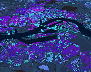
The largest telecom in the world uses a digital twin to predict how weather conditions might affect their infrastructure—present day, in three years, and in 30 years. They interface with supercomputers at climate research institutes that generate scenario-based projections. Bringing in GIS data shows exactly where infrastructure might be at risk.
During one particular storm, these models successfully predicted that a central office built on a slope would partially flood. Knowing they had to secure only low ground entry points saved crews valuable time.
As climate dynamics change, so will the maps and simulations. And, the climate prediction models will inform the placement of new cell towers and cable lines and show where to build mitigation measures around existing structures.
Public works in 7D
Other cutting-edge AI-powered simulations push the operational envelope into new dimensions.
A massive public rail project is underway in Brisbane. Australia's third-largest city is prioritizing smart city infrastructure designed to reflect its cultural identity.
The project comprises two underground tubes and 1,300 km of track tunneled through the heart of the business district out to the suburbs. A dozen above-ground and underground stations will be built or rebuilt in already-developed parts of the city. A tidal river prone to seasonal flooding adds a wrinkle.
The design and execution of the project happens entirely inside a virtual simulation. Not just the stations, tracks, and tunnels—this digital twin captures 13,000 square kilometers of the city.
All crews and contractors were required to federate digital plans inside a common data environment. Data for construction, surrounding geography, drone imagery, lidar and sensor data all combined in one place.
This created a platform for experiencing AI-powered simulations in lifelike detail. Machine learning algorithms in a video game engine render the imagery and complex 3D environments. Imagine Pokemon GO! for engineers.
Within the simulation, designers experiment with aesthetic and functional details. Will the corridors have enough natural light? Will bicyclists collide with pedestrians? Should this public art exhibit face east?
Engineers consult virtual blueprints accurate to 2 millimeters and updated every four hours. 3D maps guide the work; they know the location of utility lines, sewers, and 200 other layers of geographic information.
Construction managers tap financial data to understand how much different scenarios will cost and affect timelines. The simulation tracks 200 million assets as they arrive at the jobsite.
In a 360-degree virtual reality theater, the city's train conductors gather to experience track lines before they are built so they can give feedback.
Government officials swap hardhats for VR headsets taking a virtual stroll through a construction site.
Eventually, the digital twin will serve as an operational dashboard, providing real-time data and analytics to railway operators.
Moving from Simulation to Reality
In the GIS technology community, bridging the sim-to-real gap in this way has been a priority.
Purpose-built to analyze rich, structured, and diverse datasets, GIS technology is fertile ground for the integration and training of machine learning models. With the rapid expansion of enterprise data, we can address our toughest challenges with greater certainty.
Every scenario has clues that point to the best outcome. Great executives know how to identify the ideal scenario and bring about the best outcome. GIS technology has a way of making these patterns more apparent.
GIS together with AI, as GeoAI, empowers us to explore possibilities in ways that are smarter and more holistic than ever before.
See how organizations are applying spatial problem-solving with GeoAI. And explore the advantages of AI with location intelligence from GIS.
The articles from these contributors are based on their personal expertise and viewpoints, and do not necessarily reflect the opinions of their employers or affiliated organizations.
EDITOR'S Choice

Fortune Brands Innovations [NYSE: FBIN]
By Juan Guerrero, Director, IT Audit & Data Analytics
The IT Audit Evolution: From Compliance to Strategic Intelligence
Broad River Retail
Wes Dudley, Senior Vice President, Customer Experience
Customer Experience in the Age of Amplified Complexity
Fortune Brands Innovations [NYSE: FBIN]
Scott Barnes, Sr. Director of Enterprise Cyber Security (CISO)
The X-Factor in Cybersecurity: AI and Automation at Work

LHarris Technologies [NYSE: LHX]
Brian Allred, Director of Business Intelligence and Analytics
The Shift from Rigid Dashboards to Conversational Analytics
Ivar's Restaurants
Patrick Yearout, Director of Innovation, Recruitment & Training
From Hiring to Development: Nurturing Teams that CareLatest Issues